Scale and Aerial Photography
Just like maps, vertical aerial photographs can also be defined by their scale. The scale determines how large of an area is covered by photograph and in what detail. Understanding scale is key to selecting and obtaining appropriate aerial photography for a project.
Scale
The scale of an aerial photograph is the ratio of the distance on the photo to the corresponding distance on the ground, i.e. 1 unit on the photo equals "x" units on the ground. Aerial photograph scale is usually expressed one of two ways:

- Unit Equivalent - For example 1cm= 1km
- Representative Fraction- Expressed as a unit-less ratio, 1:25,000 or 1/25,000. This is the most common way scale is expressed in aerial photographs.
Typically photographic scales are expressed as representative fractions and unit equivalent scales can easily be converted to representative fractions. For example, a photographic scale of 1 cm on the photograph represents 1 km on the ground would be expressed as follows: 1 km = 100,000 cm → 1:100,000 or 1/100,000. For film-based cameras we use the scale to describe the resolution quality on an image, while for digital cameras, we use the Ground Sampling Distance (GSD) to describe the level of detail visible.
Ground Sampling Distance
For aerial photographs acquired with a digital camera, scale is primarily expressed as the Ground Sampling Distance. The Ground Sampling Distance or GSD is the distance between the centers of two adjacent pixels in an image. Basically GSD is how big each pixel is on the ground. This is also referred to as spatial resolution. It is usually expressed in metric units, often centimeters. For example an image with a GSD of 50cm means that one pixel in the image represents 50 cm on the ground ( or 50*50 = 2500 square cm). The larger the GSD of an image is, the lower the spatial resolution of the image and the less details are visible.
Small and Large Scale Aerial Photographs
Aerial photographs can vary widely in scale, typically anywhere from 1:100 to 1: 200,000. Large scale photographs cover smaller areas in greater detail.
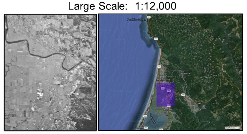 Example of a large scale aerial photograph with a scale of 1: 12,000 and the corresponding ground footprint.
 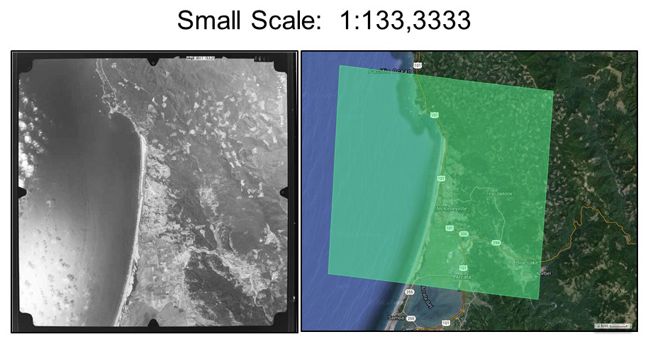 Example of a small scale aerial photograph with a scale of 1: 133,3333. Note that the footprint is significantly larger compared to the above large scale photo.
Determining Scale
The scale of an aerial photograph depends on the specific camera characteristics (focal length) and the flying height at which the image was captured. There are several methods for calculating the scale of an aerial photo. Which method you use depends on what information is already known.
Focal Length and Field of View
The scale of a photograph is determined by the focal length of the camera and the flying height above the ground. The focal length is the distance from the middle of the camera lens to the focal plane. Focal length is precisely measured when cameras are calibrated and is typically expressed inn millimeters (mm). The focal length of a lens determines the magnification and the angle of the light ray. The longer the focal length, the greater the magnification of the image. Short focal length lenses cover larger areas. The area captured by a camera is known as the Field of View (FOV), which is typically expressed in degrees. Field of View is a function of the focal length of the lens and the size (sometimes called format) of digital sensors.
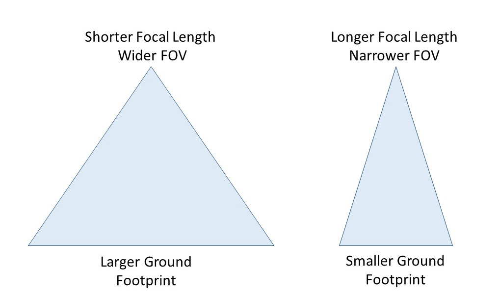 Shorter focal lengths have wider field of views, while longer focal lengths have smaller field of views. Therefore a camera lens with a longer focal length will produce an image with a smaller footprint compared to that of a shorter focal length.
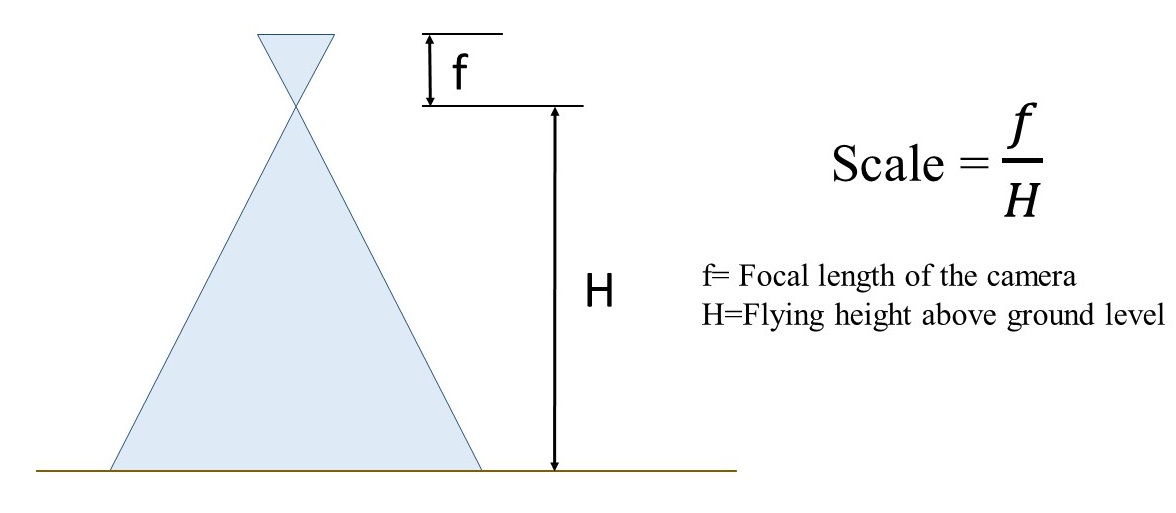
The scale of a photo is equal to the ratio between the camera's focal length and the plane's altitude above the ground level (AGL) being photographed. If the focal length and flying altitude above the surface is known, the scale can be calculated using the following formula:
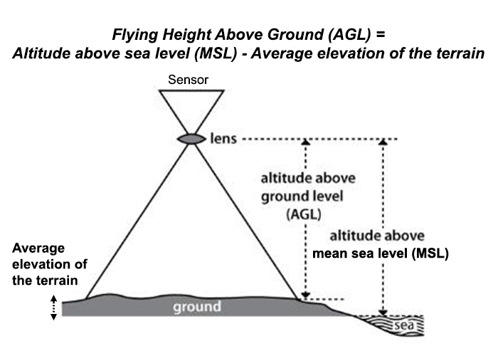
Flying Height Above Ground Level (AGL) vs Above Mean Sea Level (MSL)
In all of the scale calculations, it is important to know the flying height above the surface or above ground level (AGL). Sometime the altitude above sea level or MSL is given and you may need to estimate the average flying height above ground. For example, the GSP on a unmanned aerial vehicle (UAV) may record the altitude or height above sea level and not above ground level (AGL). To estimate the AGL, you will need to determine the average elevation of the terrain and subtract that from altitude above sea level. This will give you the average flying height above ground.
Example:
A camera with a 152 mm focal length takes an aerial photograph from a flying height of 2280m above ground level. What is the scale
of the photograph?

Feature of Known Size
The scale of an aerial photo can also be determined if an object of a known ground size appears in the image. One method is to find a feature of a known size (e.g. football field or standard event field) in the photograph to calculate the scale. The scale can be determined by measuring the distance or length of the feature on the photo and comparing it to the real-life or ground distance.
Example: You measure the straight length of a track to be 2.5 mm and you know that the real ground distance is 100 meters, what is the scale of the photo? 
Ground Sampling Distance in Digital Photographs
Ground Sampling Distance (GSD) refers to how big each pixel is on the ground. This linear measurement represents the ground width of a pixel and is typically expressed in meters. This is effectively the scale of a digital image. The size of the sensor, lens focal length along with flying height above the surface determines the GSD of an image.
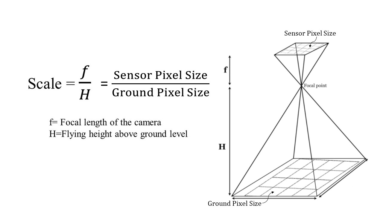 Similar to a film camera, the Ground Sample Distance or Ground Pixel Size relates to the flying height above ground and the camera lens (focal length) and sensor characteristics.
 In order to determine the GSD, you need to know the flying height above the ground (not above sea level) and the digital camera sensor size and lens focal length. This information is typically available from the camera manufacturer.
Focal Length for Digital Cameras
The focal length for digital cameras is similar to that of analog film camera. Focal length will typically be expressed in millimeters (mm). There may be a 35 mm equivalent focal length and real focal length listed for digital cameras. When determining GSD or other calculations you will want to use the real focal length.
Digital Camera Sensor Dimensions and Pixel Counts
Digital cameras use CCD (charge-coupled device) or CMOS (complementary metal-oxide semiconductor) to capture light and convert it into electronic data. The camera sensor is a rectangular grid containing millions of tiny square pixels. Each of these pixels detects and records the amount of light received. Sensors are defined by their physical size (surface area for capturing light information), the dimension of the pixels and the number of pixels in the sensor. The physical size of the sensor may be expressed in inches or centimeters. The dimension or width of each individual pixel are usually expressed in micrometers, as each pixel on the sensor is extremely small. The sensors pixels sizes vary between cameras, but are typically between 1-2 micrometers. The number of pixels a sensor has is sometimes referred to has camera resolution. For example, a camera may have a sensor with dimensions of 3000 x 2000 pixels. That means that the rectangular grid of the sensor is made up of 3000 pixels wide and 2000 pixels tall, for a total 6 million pixels or 6 Megapixels.