Distortion in Aerial Photos
All aerial imagery, whether it is acquired by a sensor on a satellite, or by an aircraft, will have some amount of geometric distortion. This is an issue in remotes sensing as we want to be able to accurately represent a three-dimensional surface on a two-dimensional image. The errors can be due to a number of factors including:
- Camera/Sensor tilt
- Camera Lens distortion
- Terrain/Relief
Most aerial photographs are taken with specialized cameras to minimize lens distortion, but some distortion is still present.
Terrain/Relief Displacement
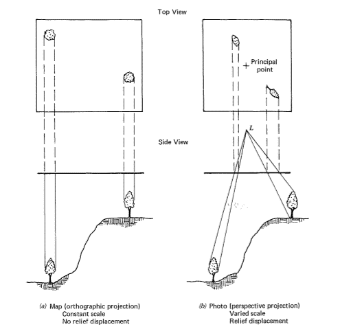
Image Credit: Lillesand
The scale of ordinary aerial images varies across the image, primarily due to the changing elevation of the terrain surface. Scale distortion is zero at the principal point (center) and increases radially from the center of the image. Therefore when scale is given for an un-rectified aerial photograph, it is actually an average scale based on the average terrain elevation for the image. On a photograph, areas of terrain (or buildings) at higher elevation lie closer to the camera at the time of exposure. Therefore they appear larger than areas at lower elevations.
The tops of tall objects are always displaced from their bases. This is known as relief displacement and causes any objects above the ground to lean away from the principal point of the photograph. The greater the distance the object is away from the principal point, the greater the displacement. The displacement also increases as the height of the object increases. Relief displacement is caused by differences in elevation. If the elevation of the terrain surface is known throughout a scene, the geometric distortion can be rectified.
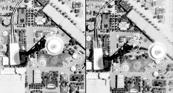
In the left image the Space Needle in Seattle was located close to the principal point so there is minimal displacement. In the right image the Space Needle is located further away from the principal point causing it the "lean" away from the center.
Orthophotographs
Orthophotographs or orthoimagery are aerial photographs that have been geometrically corrected for topographic relief, lens distortion and camera tilt. This means that the distortions have been removed and scale is uniform through out the image. This allows for the accurate direct measurement of distances, angles, and areas. Orthophotos combine the visual attributes of an aerial photograph with the spatial accuracy and reliability of a map. The process of creating orthophotos is known as orthorectification. The orthorectification process requires two main things: first, accurate information about the sensor geometry, which includes information about the sensor location and orientation for the image. The second is an accurate terrain or elevation model.
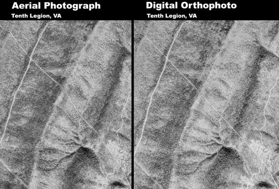
The below image shows the same area in an unrectified image on the left and an orthorectified image on the right. Notice the road that passes through the mountains in the center of the image appears to be crooked in the unrectified aerial photograph. This is due to the terrain features. The image on the right is a rectified orthophoto and the road appears planimetrically correct.