Aerial Photography
Introduction
Aerial photography is one the earliest forms of remote sensing and is still one of the most widely used and cost effective methods of remote sensing. Before the development of multispectral sensors and computers, people were using traditional photography to capture aerial images. Since its inception, aerial photography has progressed from balloons and kites, to airplane, satellites and now unmanned aircraft systems (UAS). While the quality, resolution and platforms have evolved, aerial photography is still a cornerstone of remote sensing and is becoming cheaper and more accessible than ever. Aerial photography is useful both for regional analysis and for evaluating specific sites. It can also provide a historical perspective that allows us to view changes in landscapes overtime.
As we learned earlier in this course, the first aerial photographs were taken from balloons, kites and even pigeons. Aerial photography quickly expanded with advances in aeronautics. The military potential of aerial photography was obvious and aerial photography was widely used in WWI and WWII. The first non-military aerial photography programs were developed in the 1930's as part of the Agricultural Adjustment Act. In the United States the U.S. Department of Agriculture (USDA) has been involved in the acquisition, use and distribution of aerial photography for more than 65 years. Aerial photography has numerous applications and is used by cartographers, engineers and scientists to analyze everything from urban expansion to the impacts of climate change.
History in the U.S.
In the United States the U.S. Department of Agriculture (USDA) has been involved in the acquisition, use and distribution of aerial photography for more than 65 years. The earliest aerial photography in 1937 by United States Geological Survey (USGS) and Farm Security Agency (FSA). Later the National Aerial Photography Program (NAPP) and the National Digital Orthophoto Program (NDOP) were created to take a more imagery of farm lands on a national scale and provide consistent coverage. While there have been many different aerial photography programs since the mid twentieth century, in the 1980s national aerial photography programs were developed to capture aerial images of the entire U.S.
A large collection of aerial photography is available through USGS Earth Resources Observation and Science (EROS) Archive. This can be accessed through EarthExplorer
National High Altitude Program
The National High Altitude Program (NHAP) was an interagency federal effort coordinated by the USGS which operated from 1980 to 1989. The goal of the program was to provide cloud free aerial images of the entire lower 48 states. The images were acquired at 40,000 ft. elevation. The NHAP collection includes black-and-white aerial photographs at a scale of 1:80,000 and color infrared aerial photographs at a scale of 1:58,000 Learn More About NHAP.
National Aerial Photography Program
The National Aerial Photography Program (NAPP) program began in 1987 as a replacement for NHAP, with the objective of acquiring complete uniform photo coverage of the conterminous 48 States over a 5 to 7 year period. The NAPP photos include black-and-white and color infrared images and all images have a scale of 1:40,000 (1 inch equals about 0.6 miles). Learn More About NAAP.
National Agriculture Imagery Program
Starting in 2003 the National Agriculture Imagery Program (NAIP) and acquiring aerial imagery during the agricultural growing seasons in the continental U.S. A primary goal of the NAIP program is to make digital ortho photography available to governmental agencies and the public within a year of acquisition. NAIP imagery is typically acquired every one to three years. NAIP imagery typically has a resolution of 0.6 to 1-meter ground sample distance (GSD). Learn More About NAIP.
Digital Orthophoto Quadrangle (DOQ)
A Digital Orthophoto Quadrangle (DOQ) is an aerial photograph in which has been corrected for terrain relief displacement and camera tilt. A DOQ combines the characteristics of the original photograph with the georeferenced qualities of a map. The USGS has produced black and white, natural color, and color-infrared (CIR) DOQs with 1-meter ground resolution. Learn More About DOQs.
Other Programs
In addition to the national aerial photography programs listed above, there are many other sources of aerial photographs. Many other federal, state and local governments have acquired aerial photographs of regions and often make this data available to the public for little or no cost. Some private companies also obtain this data and may make it available at a cost. The Aerial Photography Single Frame Records collection is a large and diverse group of imagery acquired by Federal organizations from 1937 to the present. Learn More About Aerial Photo Single Frames.
Universities and libraries are an excellent source for aerial photographs, particularly local photographs. At Humboldt State University, the Library Special Collections has a variety of historic maps and aerial photographs in the Humboldt Room. Learn More About the Humboldt Room Collection.
Types of Aerial Photography
Angle of Photo
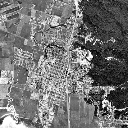
Aerial photographs may be taken in vertical, low-oblique or high-oblique positions. Most of the air photos used in remote sensing are vertical photographs.
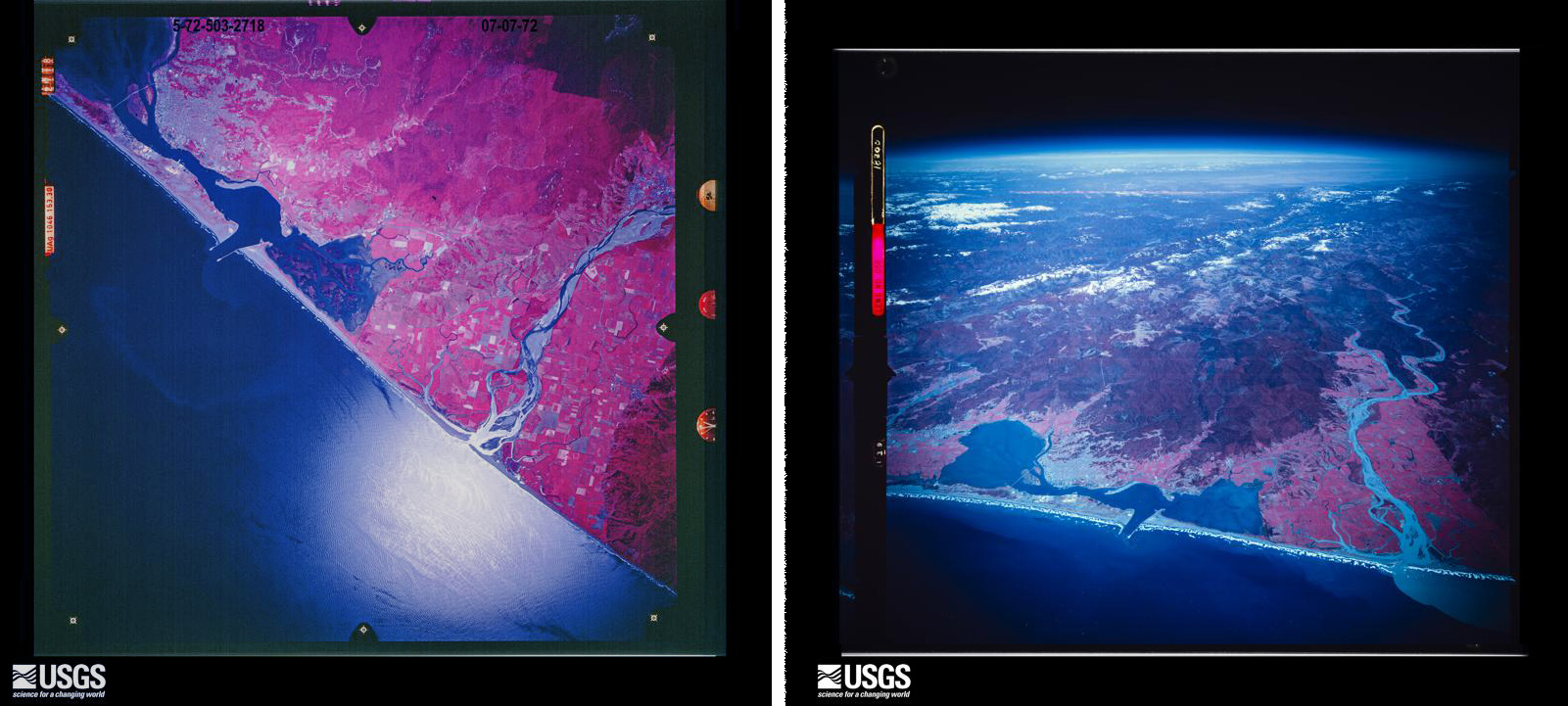
Left: Vertical aerial photograph of Humboldt Bay, Right: High-oblique aerial photograph of Humboldt Bay. Both images were acquired using color infrared film in 1972. Image Credit: USGS.
Vertical
Vertical photographs are taken looking straight down or pointing to the nadir direction or the point directly below the camera . In true vertical photography this means ±0º from nadir. In near-vertical photography the angle of the camera in relation to nadir is greater than 0º but less than ±3º. Many vertical photographs are technically "near-vertical". Vertical photograph are frequently used in cartography and photogrammetry applications. The scale of the images can be calculated, allowing objects and distances to be measured. When viewed in stereo, overlapping vertical photographs can provide information about the height of terrain and buildings.
Oblique
Any aerial photographs taken at an angle are known as oblique photographs. Oblique aerial photography includes photographs taken at angles between between ±20º degree to ±60º off nadir. Oblique photos are not typically used for photogrammetry, as the scale is not consistent in the image. Oblique photos do provide an easy to interpret image of a location. There are two types of oblique photographs:
- High-oblique -Shows the surface, the horizon, and a portion of sky.
- Low-oblique - Shows only the surface, the horizon is not show.
Film or Digital
Early aerial photography was film based and remained the dominant medium throughout the 20th century until the development of digital cameras. There are several different types of film commonly used in aerial photography.
Film Types
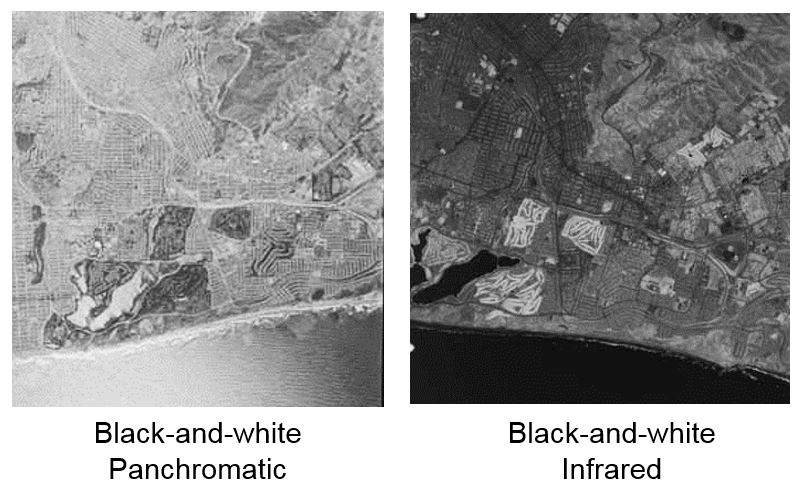
Black and White Film
- Black-and-white panchromatic (B/W) film primarily consists of a black-and-white negative material with a sensitivity range comparable to that of the human eye. It has good contrast and resolution with low graininess and a wide exposure range.
- Black-and-white infrared (BIR) film, with some exceptions, is sensitive to the spectral region encompassing 0.4 micrometers to 0.9 micrometers. It is sometimes referred to as near-infrared film because it utilizes only a narrow portion of the total infrared spectrum (0.7 micrometers to 0.9 micrometers).
 Color Film
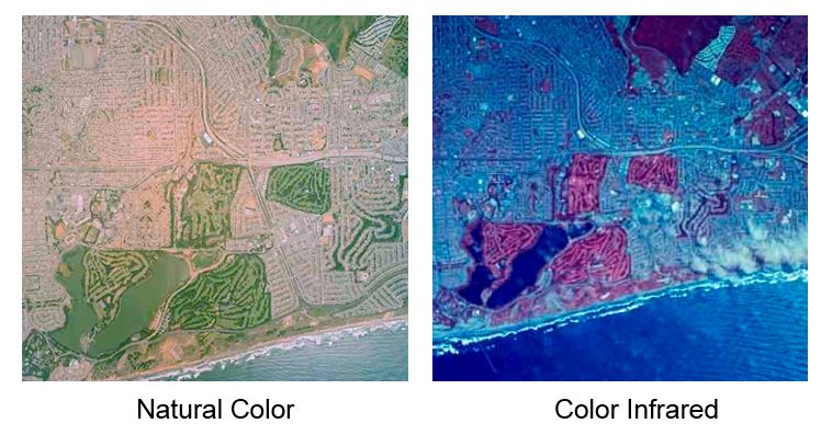
- Natural color (also referred to as conventional or normal color) film contains three emulsion layers which are sensitive to blue, green, and red (the three primary colors of the visible spectrum). This film replicates colors as seen by the human eye.
- CIR (color infrared) film, originally referred to as camouflage-detection film, differs from conventional color film because its emulsion layers are sensitive to green, red, and near-infrared radiation (0.5 micrometers to 0.9 micrometers). Used with a yellow filter to absorb the blue light, this film provides sharp images and penetrates haze at high altitudes. Color infrared film also is referred to as false-color film.
Digital
Digital photography uses CCD (charge-coupled device) or CMOS (complementary metal-oxide semiconductor) sensor to capture the image, as opposed to an exposure on photographic film. Both sensors capture light and convert it into electronic signals. The camera sensor is a rectangular grid containing millions of tiny square pixels. Each of these pixels detects and records the amount of light received. Sensors are defined by their physical size ( surface area for capturing light information ) and the number of pixels which make up this surface area (resolution). Digital has replaced traditional film photography in many applications, for example the NAIP imagery collected by the USDA is now acquired entirely with digital sensors.
Information on Aerial Photographs
Often there is a significant amount of information provided on the aerial photograph or the frame of the photo. This can be though of as an analog version of metadata. Common information can include:
Click on the aerial photo to enlarge the image
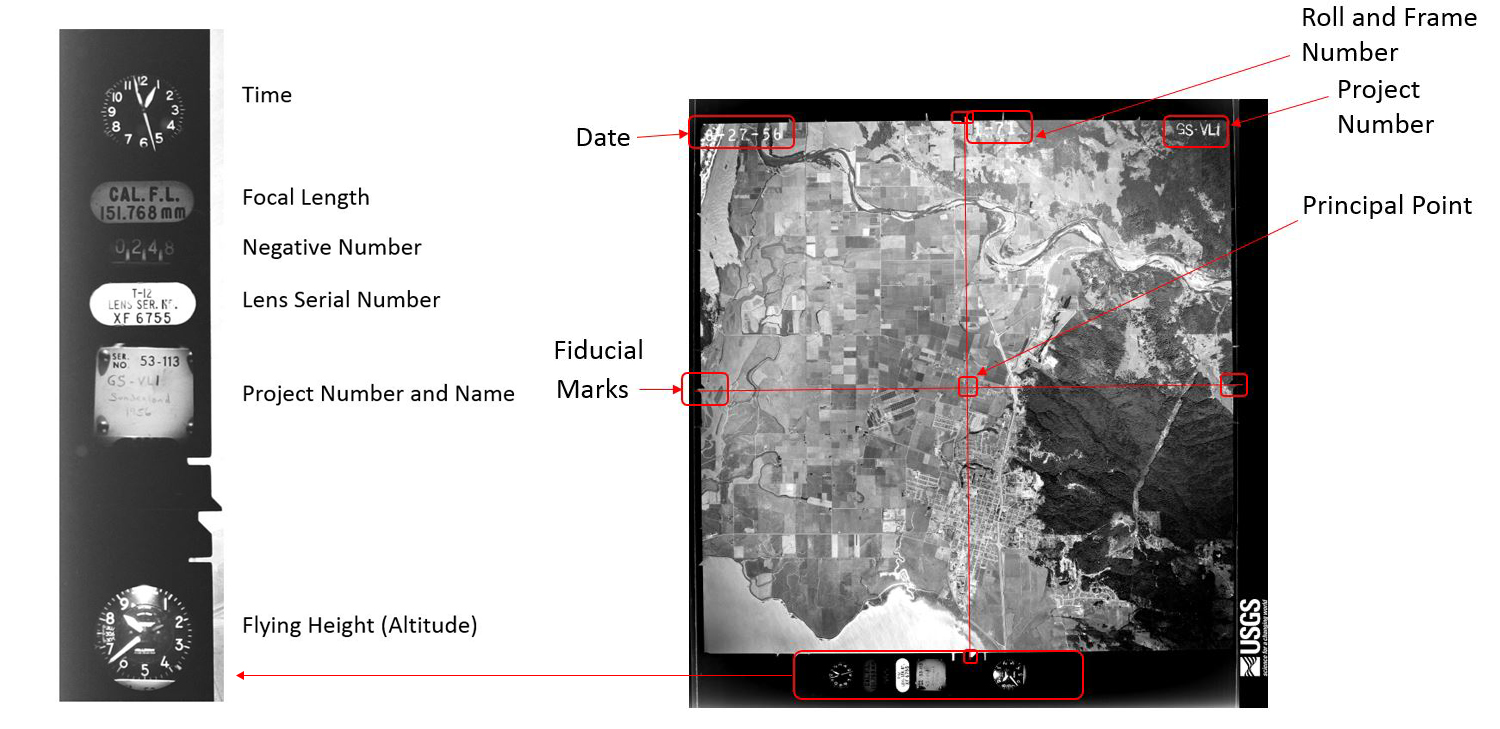
- Date
- Mission name and details
- Roll & frame number
- Fiducial marks
- Altitude