Recent Developments
Satellites
The development of multispectral sensors that were able to simultaneously record data in several different portions of the electromagnetic spectrum expanded the capabilities of remote sensing satellite. Now there are many earth resource satellites being launched by national space agencies and commercial companies. In recent years there has been a trend to producing smaller, lighter, cheaper earth observing satellites. Sensor technology has allowed for the development of smaller, powerful satellites. These satellites are significantly smaller than traditional earth observing satellites and being produced by private companies for a variety of uses.
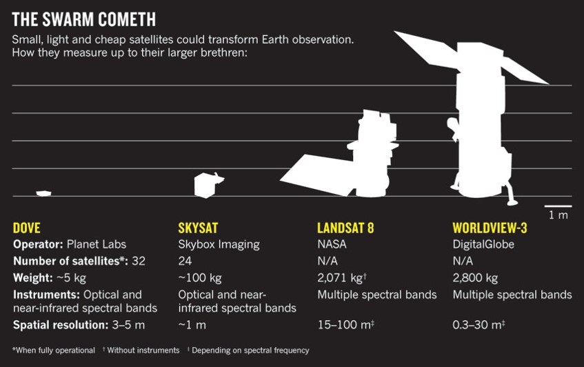
A recent trend is the production of smaller, cheaper satellites. These satellites are easier to launch and offer many advantages to the traditional large satellites. Image Credit: Nature 2014.
Satellite imaging has revolutionized our knowledge of the Earth, with detailed images of nearly every street corner readily available online. In recent years there has been a significant increase in the number of commercial imaging satellites. The majority of these satellites are small and relatively low-cost compared to their predecessors. These small satellites are typically launched in groups and are known as satellite constellations. These constallations of small satellites work together to provide global coverage (or close to), such that at anywhere on Earth can be viewed on a daily basis. One of the more notable companies employing this technology is Planet, formerly known as Planet Labs. Planet's CEO Will Marshall says" we can do better and go faster — by getting smaller". He introduces his tiny satellites — no bigger than 10 by 10 by 30 centimeters — that, when launched in a cluster, provide high-res images of the entire planet, updated daily. These constellation satellite systems have gained significant popularity in recent years.
Since their founding in 2010, Planet has launched hundreds of small satellites and has over 150 currently active. While earth observing satellites can provide an immense amount of data and knowledge, there has been a proliferation of space debris since the advent of satellite technology. As Natalie Panek points out in the below Ted Talk, "Earth orbit is not a limitless resource, and the problem of space debris will get worse without a significant change to our behavior."
Unmanned Aircraft Systems (UAS)
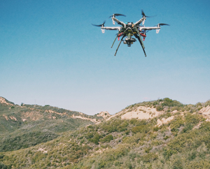
A small unmanned aircraft system (sUAS) includes the small unmanned aircraft or vehicle as well as any associated systems. In the United States the Federal Aviation Administration (FAA) is responsible for regulating UAS use. The FAA defines a small unmanned aircraft as an unmanned aircraft weighing less than 55 pounds. The FAA regulates the use of small unmanned aircraft in the United States under two parts of Title 14 of the Code of Federal Regulations (CFR), Part 101 and Part 107. Part 101 relates to model aircraft and recreational use (or what is often referred to as hobby use). Part 107 applies to the non-hobby or non-recreational use of small unmanned aircraft systems. It is currently legal for hobbyist to fly small UAS (less than 55 lbs) under 400 ft. Those interested in using UAS for research or commercial purposes must obtain a remote pilot certificate through FAA.
These small, and relatively affordable platforms are ideal for fire and natural disaster monitoring, wildlife observations and vegetation measurements. UAS can be deployed relatively quickly, repeatedly and at low altitudes and allowing for the acquisition of very high spatial resolution data. Optical digital cameras and other sensors have also become smaller and have fallen in price in recent years. This has created to perfect environments for increased use of UAS in observation, mapping and scientific analysis.
Activity: Lab 1
In this first lab we will become acquainted with the software, geospatial data and the importance of using a standardized folder structure. We will also learn about some of the current applications of remote sensing.