History of Remote Sensing
Aerial Photography
Early Aerial Photography
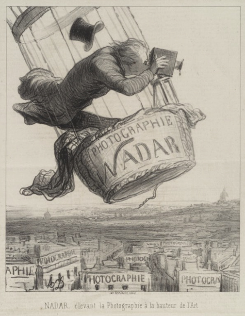
Image Credit: Online Collection
of the Brooklyn Museum
The term "remote sensing" is a relatively new term and was first used to describe the field in the 1960s. While the term remote sensing wasn't coined until the mid-twentieth century, remote sensing first began nearly 150 years ago. Aerial photography is the earliest form of remote sensing. This began with the invention of the camera in the 1800s. The first successful photographs were produced in the early 1800s by French inventor Nicéphore Niépce. Soon after the development of photography, people became interested in taking aerial photographs. The earliest aerial photographs were taken from balloons.
In 1850 Gaspard-Félix Tournachon, more commonly known by his pseudonym Nadar, captured the first aerial photograph. Using a hot air balloon, Nadar produced the first successful aerial photograph of a French village in 1858. Unfortunately none of these early aerial photographs exist today. The oldest aerial photograph that has survived was taken in Boston in 1860 by James Wallace Black. Nadar's earliest surviving aerial image was taken from a balloon above Paris in 1866.
In the early 20th century remote sensing images were captured using kites and even with cameras mounted on pigeons. In Europe carrier pigeons were already being used in military communication and aerial reconnaissance was an appealing application. Small light weight cameras were attached to the birds and photos were automatically taken using a timing mechanism. The pigeon photography was successful but didn't become widely used due to the rapid development of aviation technology.
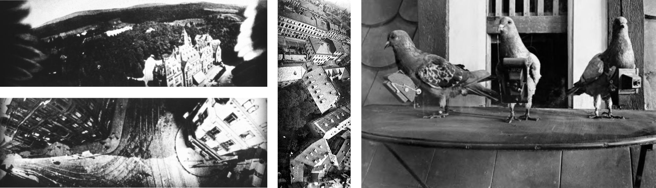
Collage of pigeons with Julius Neubronner's cameras and three aerial photos taken by the method. The photos were taken in the early 1900s in Germany.
In 1906 professional photographer George Lawrence used a string of kites to raise a 49 pound camera 1000 feet in the air to capture the devastation of the earthquake in San Francisco. The steel kite line carried an electric current to remotely trigger the shutter. The famous photograph "San Francisco in Ruins" was taken 6 weeks after the earthquake and subsequent fires in San Francisco.
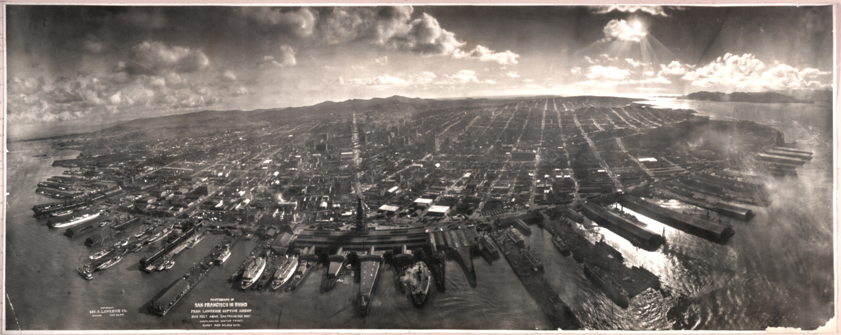
“San Francisco in Ruins,” by George Lawrence 1906
Aerial Photography in the 20th Century
The first aerial photographs taken from an airplane were in 1909, by Wilbur Wright. By the first World War, cameras mounted on airplanes provided aerial views of large surface areas that proved invaluable in military reconnaissance. By World War II airplanes were commonly equipped with cameras, in fact allied forces recruited a team of experts to review millions of stereoscopic aerial images to detect hidden Nazi rocket bases. During the Cold War the use of aerial reconnaissance increased with U-2 aircraft flying at ultra-high altitude (70,000 ft) to capture imagery. Aerial photography grew quickly following the war and was soon employed for a variety of purposes. These new photographs provided people a realistic vantage of the world few had seen before. Aerial photography was a much faster and cheaper way to produce maps compared to traditional ground surveys. In the United States aerial photography was used for farm programs beginning in the Dust Bowl Era of the 1930s with the passing of the Agricultural Adjustment Act. The agency then known as the Agricultural Adjustment Administration (AAA) began its aerial photography program in 1937 and by 1941 the AAA has flown and acquired aerial photographs of more than 90% of the agricultural land in the US. The Agriculture Department's aerial photography program became a tool for conservation and land planning as well as an instrument of fair and accurate measurement. The agricultural agencies have since been consolidated and are now known as Farm Service Agency (FSA). The FSA is still responsible for aerial imagery programs in the US. Aerial photography remained the primary tool for depicting the Earth's surface until the early 1960s.
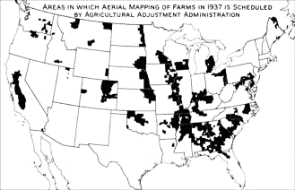
Image Credit: Harry Tubis, “Aerial Photography Maps Our Farmlands: the Program of the Agricultural Adjustment Administration”. Map showing the initial farm lands photographed in 1937.
Satellites
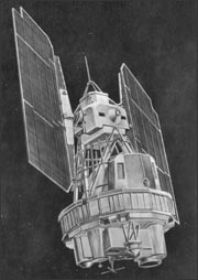 Illustration of Landsat 1
The development of satellite based remote sensing began with the "space race" in the 1950s and 1960s. In 1957 the Soviet Union launched Sputnik 1,the world's first artificial satellite. The United States followed in 1960 with the successful launch of Explorer 1. The next decades brought about rapid developments in satellites and imaging technology. The first successful meteorological satellite (TIROS-1) was launched in 1960. In 1972 Landsat 1, the first earth resource satellite was launched by the US. The original goal of the Landsat program was to collect data from the Earth through remote sensing techniques. Landsat 1 was originally named Earth Resources Technology Satellite 1 and was later renamed Landsat 1. The Landsat program has continued for 45 years with Landsat 8 launched in 2013.
Since the launch of Sputnik in 1957 thousands of satellites have been launched. There are a myriad of commercial and government satellites in operation today, many of which are used for remote sensing applications. There are currently over 3,600 satellite orbiting the Earth, but only approximately 1400 are operational. Of these satellite, well over 100 are earth observing satellites that carry a variety of different sensors to measure and capture data about the Earth. These satellites are often launched by governments to monitor Earth's resources, but private commercial companies are becoming increasingly active in launching earth observing satellites as well.
Explore
Interactive graphic: Every active satellite orbiting earth - A visual graphic that shows the active satellites by the size and color coded by their country.