Geometric Correction
Introduction
All raw aerial imagery contains some degree of geometric distortion. These distortions are due to variations in sensor position, the fact that the Earth is rotating on its axis as images are being recorded, earth curvature and finally due to terrain effects (relief displacement). Some distortions are predictable and can easily be fixed, while others are more complicated and difficult to remove from data.
The purpose of the geometric correction processes is to compensate for the distortions and to ultimately produce a corrected image with a high level of geometric integrity. If images are not corrected for geometric distortions, the x,y location of a given pixel will not be in the correct geographic location. Most satellite imagery that is commercially available or that is made available through government agencies (e.g. USGS) has been corrected for geometric distortions. These distortions can be categorized as either systematic or random.
Systematic Distortions
Some distortions, such as the effects of the Earth’s rotation and camera angles, are predictable. These are known as Systematic Distortions. Since they are predictable, correction values can be applied systematically. For example, data collected from satellites have distortion due to the eastward rotation of the earth beneath the satellites scanner. This leads to each sweep of the scanner to cover an area that is slightly west of the previous sweep, producing skew distortion. A process of deskewing corrects for this by off-setting each successive scan line slightly to the west.
Random Distortions
Distortions can also occur due to changing terrain (relief displacement) and variations in the sensor altitude. These are non-systematic, and are known as Random Distortions. They are more difficult to address compared to systematic distortions, as they are not predictable. some sensors or satellites have on-board systems to measure slight movements in the sensor. This data can be used to geometrically correct images. Ground control points (GCPs) and Digital Elevation Models are used to minimize terrain distortion.
Georeferencing and Rectification
Georeferencing is the process of aligning geographic data to a known coordinate system so it can be viewed, and analyzed with other geographic data. Georeferencing may involve shifting, rotating/skewing, scaling, skewing, and in some cases warping, or orthorectifying the data. Many raster datasets need to be georeferenced before any they can be viewed or analyzed with other geographic data. For example, historical aerial photographs and maps are available through EarthExplorer, but these images are not generally georeferenced.
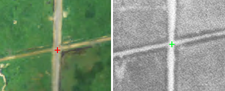
Once you have obtained a raster that you would like to georeference you need to obtain reference data. This can be a data layer with a known coordinate system or data collected in the field. If you are using a layer with a known coordinate system you will need to identify Ground Control Points (GCPs). Ground control points are locations with known coordinates that can be easily identified in an image. Some examples of good GCPs are road intersections, stone wall boundaries, building corners, and solitary trees that can be easily identified on the data layers. If you are working with historical imagery you need to select GCPs that have not moved or changed over time. Ground control points can also be collected in the field with GPS. The control points create a link between the data sets and allow us to georeference images.

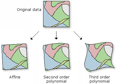
The control points are used to build a polynomial transformation that will shift the un-georeferenced raster dataset from its existing location to the spatially correct location. The connection between one control point on the raster dataset (the "from" point) and the corresponding control point on the aligned reference data (the "to" point) is a link. Control points ideally should be well distributed throughout the image, in each of the corners and middle of the image. When you've created enough links, you can transform—or warp—the raster dataset to permanently match the map coordinates of the target data.

The higher the transformation order, the more complex the distortion that can be corrected. However, transformations higher than third order are rarely needed. Higher-order transformations require more links and, thus, will involve progressively more processing time. In general, if your raster dataset needs to be stretched, scaled, and rotated, use a first-order transformation. If, however, the raster dataset must be bent or curved, use a second- or third-order transformation.
Orthorectification
Orthorectification corrects for distortions from sensor tilt and the Earth's terrain (relief displacement). This process requires more information than georeferencing. Generally, to orthorectify a raster dataset you will need the rational polynomial coefficients (RPCs) and an accurate digital elevation model (DEM). RCPs are usually provided by the producers of the imagery and require knowledge of the sensor or camera. There are some specialized programs that are designed to generate RCPs and complete the orthorectification process. Most satellite data like Landsat and MODIS have been orthorectified.
