Pre-Processing
Introduction
Before any data analysis or image interpretation can take place, raw data often need to be corrected and adjusted for errors. Pre-Processing is the general term used to describe all techniques that are employed to correct for radiometric and geometric errors that can occur in remote sensed data. When imagery is acquired, various types of errors can be introduced into the data. These errors can be caused by the sensor movement, orbital characteristics and atmospheric and environmental conditions.
Pre-processing
Pre-processing includes the initial processing of raw (or minimally processed) data to correct for distortions and errors. These errors can be categorized as radiometric and geometric errors.
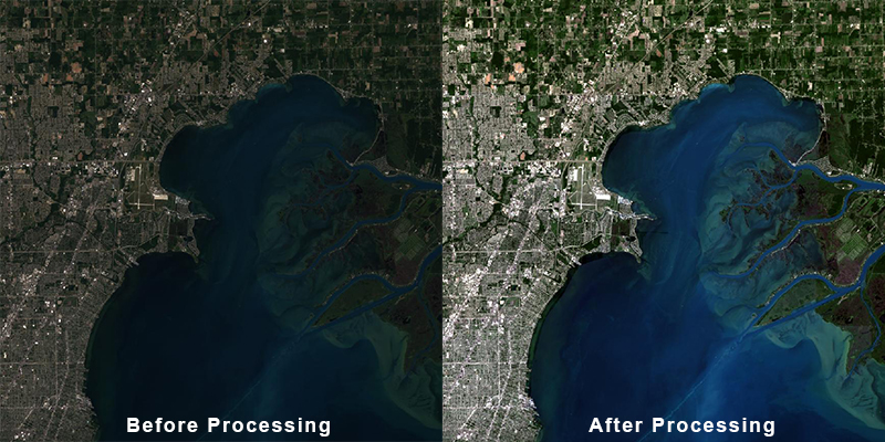
Radiometric errors produce inconsistencies in the pixel values of an image. These can be caused by issues with the sensors and by environmental factors. For example, sometimes a sensor fails to properly collect data in part of the image or in a particular wavelength or band. This can lead to gaps in the data or what is known as “striping”. Environmental factors including the atmosphere, topography and time of day and year can also cause errors or inconsistencies in the values. Images taken from different angles and during different times of the year can also impact radiometric accuracy. Radiometric calibration and correction aim to minimize errors and normalize datasets.
Geometric errors produce spatial distortion in images and image pixels not being aligned to their proper geographic location. These distortions are due to variations in sensor position, satellite orbits and terrain effects. Some distortions are predictable and can easily be fixed, while others are more complicated and can be difficult to correct for.
Pre-processing can also include other techniques like mosaicking, georeferencing and pansharpening that can make a data set more functional. Other types of pre-processing can include:
- Noise Removal and De-striping
- Compositing Images for Cloud Removal
- Mosaicking
- Pansharpening
The choice of specific processing techniques or algorithms to use depends on the data and goals of each individual project.
Why Pre-Processing?
Pre-processing is a crucial step in the use and analysis of remote sensed imagery. This is often a time consuming and expensive process and can sometimes take longer than the actual analysis. Pre-processing improves the quality and accuracy of the data. This step is also very important when analyzing temporal changes. Determining the level of pre-processing necessary for analysis is an important first step in any project. The level of processing can vary depending on the data and the project goals.

Landsat 8 image of Detroit and Lake St Clair before and after radiometric processing.
