Future of Remote Sensing
Introduction
Remote sensing provides tools for gathering data and solving real world problems. As technological advances continue, so will the quality and access to remote sensed data. What will the future bring to remote sensing? One could simply say that the future will bring better, faster and smaller technology to remote sensing. Several trends that will continue are: the decreasing size of electronics and sensors, increases in computing power, increases in transmitting power for active systems, and increasing "tunability" of systems.
All of this will translate to advancements in the spatial, spectral, radiometric, and temporal characteristics of sensors. As sensors become more powerful and compact this will produce more accurate and precise data. Smaller sensors can also be mounted on a variety of platforms allowing for greater flexibility in data collection.
Resolution
Spatial Resolution
Newer satellites are capable of producing extremely high resolution imagery. Commercial satellites like DigitalGlobe’s Worldview-3 satellite already provide extremely high spatial resolution data, although this data is costly to obtain. Another trend is smaller satellites that are being launched into lower obits. The lower orbits compensate for the smaller size of the satellite and sensors therefore these satellites are still capable of producing relatively high spatial resolution imagery.
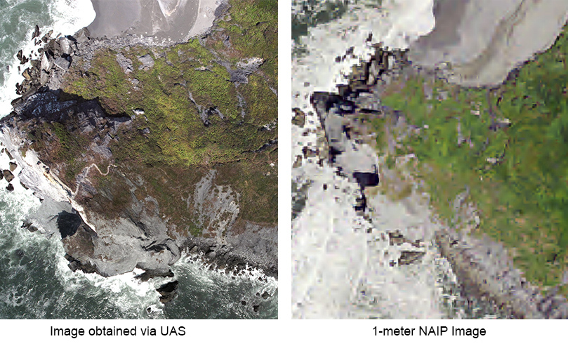
Unmanned Aircraft (or Aerial) Systems (UAS) are an emerging platform for collecting remote sensed data. UAS has allowed for increased spatial resolution at a fraction of the cost of obtaining commercial imagery from satellites like the Worldview-3. Most UAS fly at extremely low altitudes of less than 400 ft which produce much higher resolution data. We will discuss UAS in more detail in the next section.
Spectral Resolution
A variety of sensors are now capable of recording data in hundreds of bands. This produces what is known as Hyperspectral data. Hyperspectral data sets are generally composed of about 100 to 200 spectral bands of relatively narrow bandwidths (5-10 nm). Hyperspectral remote sensing is also sometimes known as imaging spectroscopy and is still a relatively new technology. Hyperspectral remote sensing has been used in the detection and identification of minerals, terrestrial vegetation, and man-made materials and backgrounds. Data can be expensive to obtain and significant computing power and large data storage capacities are needed for analyzing hyperspectral data. Hyperspectral imagery is typically collected (and represented) as a data cube with spatial information collected in the X-Y plane, and spectral information represented in the Z-direction. The top of the cube is usually a false-color image while the sides of the cube are slices showing the edges of the top in all bands. The tops of the sides are in the visible part of the spectrum (wavelength of 400 nanometers), and the bottoms are in the infrared (2,500 nanometers). The sides are pseudo-color, ranging from black and blue (low response) to red (high response).
 Datacube collected by AVIRIS of Jasper Ridge, CA.
The Airborne Visible Infrared Imaging Spectrometer (AVIRIS) is a hyperspectral system developed by the Jet Propulsion Laboratory (JPL). The sensor collects reflectance data in 224 spectral bands ranging from 400 to 2500 nanometers. AVIRIS is an aircraft based sensor that collects nearly continuous data across the spectrum. A variety of AVIRIS data can be downloaded through the NASA/JPL AVIRIS website.
Temporal Resolution
UAS technology and constellations small of earth imaging satellites have brought about rapid improvements in temporal resolution. UAS systems allow the user to control the return time, collecting multiple datasets a day if desired. Constellation satellites have multiple satellites in low orbit working together provide shorter return time, often with daily coverage.
Small Satellites
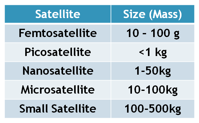
In 2013 an estimated 92 micro/nano satellites were launched, and many more small satellites were launched. Small satellites are classified as any satellite less the 500 kg (approximately 1100 pounds). Small satellites are significantly smaller than traditional satellites and are therefore cheaper to produce. They often use readily available, consumer grade technology in their construction. These satellites are cheaper to launch due their small size and weight. Many of these satellites have been launched on rockets with other payloads and supplies and are released into orbit by the international space station. The Dove satellites developed by Planet Labs are nanosatellite that weight approximately 5kg. Nearly 100 Doves satellites have been launched over the past couple of years provided a constellation or network of satellites to collect data. These satellites are capable of producing daily imagery with 3-5 spatial resolution.
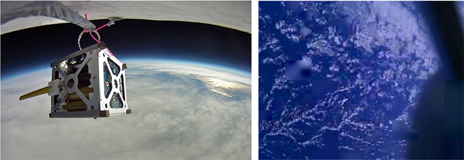
NASA's PhoneSat project is an on-going project to test whether satellites can be built using smartphone technology. The first PhoneSat cube satellites were some of the lowest-cost satellites ever flown in space. Each PhoneSat nanosatellite was one cubesat unit which consisted of a satellite in a 10 cm (approx. 4 inches) cube which weighed approximately three pounds. The construction cost of the first generation PhoneSats was approximately $3,500. The launches were successful and imagery from the PhoneSats was transmitted to Earth. This project has proved that satellites that collect imagery can be designed and launched for a relatively small price.