
UAS
Unmanned Aircraft (or Aerial) Systems (UAS) are any aircraft without a human pilot onboard and the associated systems. A UAS consists of the unmanned aircraft (UA) or unmanned aerial vehicle (UAV) and all of the associated support equipment, including the control station, data links, telemetry, communications and navigation equipment, etc., necessary to operate the unmanned aircraft. The UA or UAV is the flying portion of the system, flown by a pilot via a ground control system, or autonomously through use of an on-board computer, communication links. The term drone generally has historically been used to describe UAS that are used for military purposes, the word drone is now widely synonymous with UAS.
In recent years due to the sharply declining price there has been an explosion in the amount of UAS available for commercial and civil use. Unmanned aircraft systems allow for the inexpensive collection of high resolution data and imagery. Remote sensed imagery and data at times has been costly to obtain and the programs are primarily ran by governments and commercial companies. Relatively inexpensive UAS, GPS and camera equipment have made the collection of remote sensed data more affordable and accessible than ever.
Types
UAS can come in a variety of different types, sizes, and costs. Large UAS are often used for military and government purposes and can be large and extremely expensive pieces of equipment. Small unmanned aircraft systems (sUAS), on the other hand are under 55 pounds and are designed for commercial and civilian uses. The term micro UAS has been used to describe even smaller systems that weigh less than 4.4 pounds. There are two main types of UAVs used for remote sensing applications: fixed-wing and rotary wing.
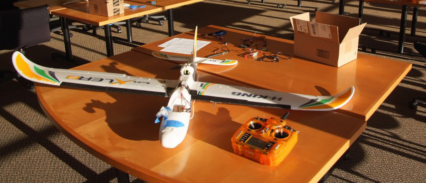
Fixed Wing
Fixed wing units have rigid wings and look similar to airplanes. Fixed wing UAVs have relatively simple construction. The simpler structure means less complicated maintenance and repair processes. The simple design and aerodynamics allow for faster speeds and longer flight times. Larger fixed wing units can carry heavier payloads. One of disadvantages to a fixed wing systems is the need for a runway or launcher for takeoff and landing and the lack of ability to hover.
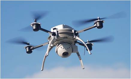
Rotary Wing
Rotary wing units rely on lift from the constant rotation of rotor blades. The rotor blades provide the aircraft with the ability to move in any direction.
Unlike fixed wing units, rotary wing units have the ability of vertical takeoff and landing, meaning they can be launched from virtually anywhere. Rotary units have the
ability to hover and move in all directions. It takes more power to sustain flight for a rotary units compared to fixed-wing systems. Therefore rotary units tend to have a much shorter flight time.
Regulations
The rapid price drop in UAS technology has brought about an explosion of UAS use in recent years. In the past decade, the US Federal Aviation Administration (FAA) has been working to address these issues and develop regulations to allow for safe and appropriate operation of UAS.
The FAA regulations regarding UAS vary depending on the application and the operator. These regulations are commonly referred to in the UAS community as “Part 101” and “Part 107”, in reference to the sections of the United States Code of Federal Regulations that regulate UAS activities. These regulations apply to unmanned vehicles that weight less than 55 pounds that are classified as small UAS (sUAS). Part 101 regulations govern UAS that are only flown for hobby or recreational purposes. Currently under Part 101 regulations, flying a UAS for a hobby or recreational purpose does not require special FAA licensing or approval. Regardless of the application, all UAS must be registered with the FAA if they are will be flown outdoors and weigh more than 0.55 pounds. FAA recreational regulations dictate that UAS should be operated below 400 feet, be a sufficient distance from populated areas and full scale aircraft, should be kept within visual line of sight of the operator and cannot be used for business or research purposes.
Specific regulation apply to those wishing to use UAS for commercial or research purposes. Small UAS (less than 55 pounds) can be flow for work or business under the Part 107 guidelines. To fly a UAS for commercial purposes under Part 107 regulations one must posses a Remote Pilot Certificate issued by the FAA. This process includes passing an aeronautical knowledge test at an FAA-approved knowledge testing center. The operating rules for commercial pilots are similar to those for hobbyist. By default, commercial UAS pilots are restricted to flying below 400 ft above ground and speeds less than 100 mph. Operations should not be conducted over people, from a moving vehicle or at night. Those flying under Part 107 may apply for a waiver from the FAA to allow for certain activities (like flying at night) that are normally not permitted.
Government organizations can be granted a Certificate of Waiver of Authorization (COA) issued by the FAA to grant access for a specific UAS activity. COAs contain requirements the holder must follow. These can be obtained for research purpose but require advance planning.
The FAA is continuing to develop and revise regulations in relation to UAS. For example, in the future the FAA has proposed that even recreational operators will need to pass an online aeronautical knowledge and safety test and carry proof of test passage.
Applications
UAS can be used to acquire aerial photographs and conduct aerial mapping. Although any camera can be used to obtain images with a UAS, for accuracy mapping and aerial imagery collection ideally a specialized cameras should be used to minimize distortion. UAS are also capable of carrying a variety of multispectral sensors and lidar systems. Structure from Motion software can be used to derive point cloud data and to create DEMs from from aerial images. The high spatial revolution and variable return times make UAS an ideal platform to conduct a variety of research.
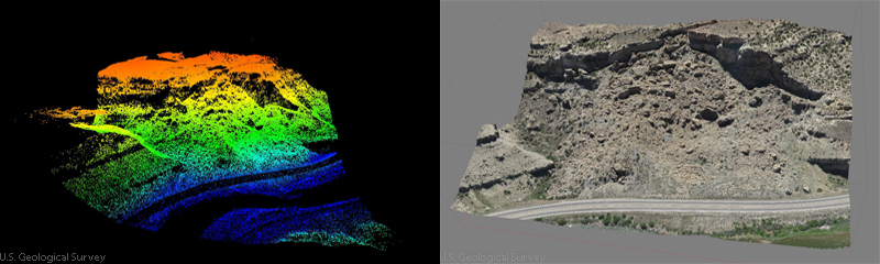 Point cloud data derived from 1149 images via UAS from approximately 400 feet above ground level over the Debeque Landslide in Mesa County, Colorado. Left image is point cloud 3D data is derived in the Agisoft PhotoScan software and Right image is mosaicked aerial photographs draped over digital terrain model to create a 3-D image. Image Credit: U.S. Geological Survey