
Applications and More
Modeling and Decision Making
Remote sensing can increase the capability and predictive power of models of the Earth’s systems. Data collected by remote sensing systems can provide more accurate and up-to-date inputs for a variety of models. Advances in sensors and data analysis techniques are making remote sensed data extremely useful in monitoring and modeling ecosystem changes. The variety and amount of remote sensed data available has increased dramatically in recent years and will continue to increase in the future.
Managers and scientist need up-to-date and cost-effective related information to develop functional strategies for dealing with a growing population and changing planet. While single data sets can provide significant information, combining several data sources will often increase and improve knowledge. This is especially important because Earth’s systems are complex and interconnected. Remote sensing also allows us to study and measure phenomena that we can’t see and in places we physical can’t visit.
Ultimately remote sensing ultimately provides us with a better understanding of the Earth. There are many benefits which will come from a better understanding of the Earth including: weather prediction, understanding and analyzing the implications of climate change, studying water resources, developing strategies for wildland fire management and many more.
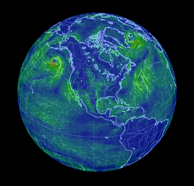
Remote sensing can also be used to create amazing visual models and representation of Earth's systems. The visualizations can be used for scientific purposes and to better inform to general public. One example is the website http://earth.nullschool.net/ which provides a a visualization of global weather conditions that is updated every three hours. The data is collected from a variety of remote sensing satellites.
Open Source and Other Technology
On a final note there has also been an increase in alternative, open source and do-it-yourself (DIY) technology that is being applied to remote sensing. This technology and approach has made remote sensing more approachable and affordable for the everyday person.
GoogleEarth Engine
Google Earth Engine is a cloud-based platform for global environmental data analysis. There are several components of Google Earth Engine that make it ideal for remote sensing analysis.
The first is the datasets available through Google Earth Engine. The data includes Landsat, MODIS, Sentinel and many more. Google touts a petabyte-scale archive of free, publicly available remotely sensed imagery and data. Explore the Google Earth Engine data catalog. One of the second big advantages is that Google Earth Engine takes advantage of Google’s computational infrastructure optimized for parallel processing of geospatial data. This means it is feasible to access years of data across vast areas and perform extensive analysis without having to rely on local computing power and storage limitations. Google Earth Engine also has a significant amount of tutorials and training available at no-cost.
Open Source and DIY
Open source software and do-it-yourself (DIY) solutions are being applied to remote sensing. Public Lab is community that focuses on developing and applying open-source tools for environmental analysis. Some of the applications they have developed are Kite and Balloon Mapping, DIY Spectrometers and DIY NIR Cameras.
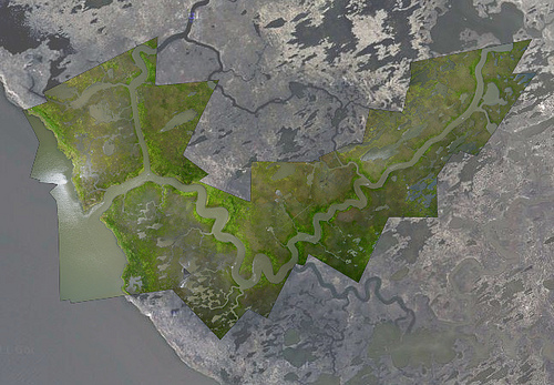
Balloon mapping techniques were used to map and produce imagery of the Gulf Coast following the Deepwater Horizon oil spill. The imagery produced from the balloon mapping was released as public domain. Browse maps and data from the Gulf Coast and elsewhere in the Public Laboratory Archive.
Research has been done to investigate the conversion of standard digital cameras to near-infrared (NIR) detecting cameras. Most standard digital cameras have a sensor that detects visible and NIR light but have infrared blocking filters. By removing the infrared filter and replacing it with a blue filter the camera detects the near infrared light in the rad channel. This creates a camera the detects and records light in the near infrared, green and blue wavelengths. Used in conjunction with an unaltered camera, four band (NIR and RGB) imagery can be created. These techniques are inexpensive and relatively easier to try.
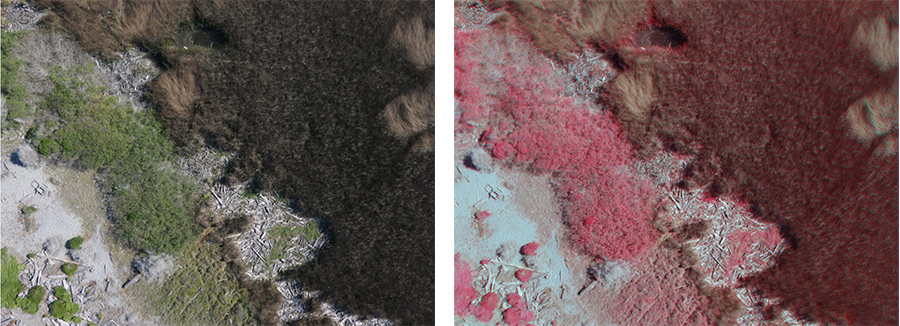 True color image and near infrared false color composite collected by a DYI NIR camera. Image Credit: Chris Muhl