Help for Contributors
If you are new to the archive, please checkout the Home page.
This help assumes you are familiar with the terms scope, category, and area as they are used within the portal. The help also assume you are familiar with common file formats, data types, and spatial references used in geospatial applications.
Adding Datasets Using the Web Site
To uploads datasets on the web site, only verified users with an account are able to access the Uploads page. Uploading through the website can also have a desingated CPHMetadata.txt file or one will be created in place. The uploads page is able to take in only ZIP files under 350 MB at the moment.
Adding Datasets Directly to the Archive
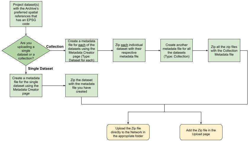
Note: Please only add high quality final datasets to the archive in spatial references that are supported and with metadata in the format defined below. If data is found to be outside the specified requirements, it will not be added to the website and will be removed from the archive.
The most straight forward way to add data to the archive is a single dataset. This would be a single shape file or TIFF file.
- Review the data for completeness, accuracy and errors and address any issues.
- If needed, please project the data to a standard spatial reference that has an EPSG code, as coordinate systems that do not have an EPSG code are not supported. The following spatial references are preferred:
- WGS84 for datasets with an extent that is too large for other commonly used spatial references. This might include data for North America.
- WGS84, UTM for datasets that fit within a single UTM zone (or almost fit). This would include:
- WGS84, UTM Zone 10 North: for datasets for Northern California.
- NAD83, State Plane: this spatial reference system is not recommended but is readily used by government agencies. This includes:
- NAD83, State Plane California Zone I for datasets in northern California.
- Create a metadata file to accompany the dataset. The format we use is a relatively simple format based on standards and what we have seen is commonly used and of value to end users and curators of the data. The file name must be titled "CPHMetadata.txt" in order to ensure that the metadata can be read and populated on the archive website. The following is an example of the contents of a file. Please refer to the "Metadata Terms" in the Help page to learn what fields are required for the metadata. Below is an example what is expected in a "CPHMetadata.txt" file:
- Zip the dataset files and the CPHMetadata.txt file into a single zip file. Please use a plain "zip" file as 7z is a commercial project.
- Give the zip file a file name that uses the following format (note that this is not currently strictly required as the folder provides the scope, area, and category)
- For Vector data: scope_area_category_description_date.zip
- County_Humboldt_CA_Built_countyroads_20200514.zip
- For raster data: scope_area_category_description_resolution_date.zip
- City_Arcata_AerialImagery_3inch_2020.zip
- For Vector data: scope_area_category_description_date.zip
- Store the zip file in the correct folder in the archive located at:
- \\storage.humboldt.edu\Academic\GSP-Database
- Note that it is critical for the zip file to be in the correct folder for users to find the data.
- The zip file will be proceeded within a week and will be available on the website if there are no major errors. If errors do occur, you will be notified through email and you will be able to update the zip file by replacing it or by editing the metadata on the website. If not email is available, the curators will remove the dataset from the archive.
Below is a flow chart showing the process of uploading datasets and collections to the network drive (\\storage.humboldt.edu\Academic\GSP-Database)
Metadata Descriptions
Below are descriptions of the metadata that you'll add with your datasets.
General Dataset Information
- Title: Descriptive name for the dataset
- Type: Determines if it is a dataset, collection, or project
- Dataset: A single file (.shp or .tif) with one CPHMetadata.txt file
- Collection: Multiple files for the same original data (e.g. tiled aerial photos) with one CPHMetadata.txt file
- Project: Multiple files from different sources of data with a CPHMetadata.txt file for each of the datasets
- Status: The condition of the dataset when entered into the system
- Empty: Dataset that contains no data or features
- Completed: Finished datasets
- Historical Achive: Datasets from a past time period
- Obsolete: Datasets that are no longer in use or outdated
- On Going: Datasets that are currently in progress
- Planned: Datasets that are to be developed in the future
- Required: Necessary datasets for a specific purpose
- Under Development: Datasets that are still being worked on and not yet released
- Description: Detailed information about the dataset (provide context about the GIS data: purpose, data collection, inteded use, etc.)
- Tags: Words to filter datasets
- Keywords: Additional words about the dataset that users might search by
- Start Valid Date: The date that the data starts to be valid. This would typically be the start of the data collection that was used to create the dataset.
- End Valid Date: The latest date that the data is valid for. This would typically be the end of the data collection that was used to create the dataset.
Basic Structure
The following metadata elements give us a basic structure to store data in the networked drive.- Scope: The type of area that the data covers (e.g. Bay, County, City...)
- Area: Specific geographic region the data covers (e.g. Humboldt County, Washiington DC...)
- Category: General themic type of the data (e.g. Aerial Imagery).
Allowed Usage
- Use Constraints: Limits on the use of the data (e.g. cannot be used for monetary gain)
- Access Constraints: Who can access the data (e.g. public, CPH only)
- License Holder: The individual(s) or organization(s) that holds the copyright for the dataset
- License: The legal restrictions on how a dataset may be used
- Unknown: The legal restrictions are not specified
- Public Domain: Ceative works not protected by copyright and can be used, altered, distributed without permission
- CC-BY: (Creative Commons Attribution) license that allows users to distribute
- CC-BY-SA: (Attribution-ShareAlike) license that allows users to distribute, including comercially, modify, and build on the work as long as they credit the original creator
- CC-BY-ND: (Creative Commons Attribution - No Derivatives) license that allows redistribution, including comercially, with no modifications as long as they credit the original creator
- CC-BY-NC: (Attribution-NonCommercial) license that allows distribution and modifications only for non-commercial purposes
- CC-BY-NC-SA: (Creative Commons Attribution-NonCommercial-ShareAlike) license that allows users to use and modify work only for non-commercial purposes
- CC-BY-NC-ND: (Creative Commons Attribution-NonCommercial-NoDerivatives) license that allows users to distribute without modifications as long as they give credit to the original creator and do not use it for commercial purposes
- ODbL-1.0: (Open Database License) license that allows users to distribute and modify the database
Submitter Information
- Submitted By: The name of the individual or organization that uploaded the dataset into the archive (submitter does not need to be the creator of the dataset, but original creator needs to be stated in the author or affiliation, along with having permission to do so)
- Submitter Email: The email of the person that submitted the dataset to the archive
- Submitted Date: The date when the dataset is uploaded to the archive
Responsible Parties
- Contributors: Individual(s) or organization(s) who contributed to the original dataset (not the author), or updated the contents in the dataset
- Contact Name: The name of the contributor(s)
- Contact Email: The email of the author(s)/contributor(s) behind the dataset
- Author: The creator(s) of the original dataset
- Affiliation: The organization(s) the created/published the dataset (required if author is not present)
Example CPHMetadata File
Title: Humboldt County Boundary
Description: Shows the boundary of Humboldt County in northern California.
Status: Completed
Publisher: Humboldt County
Submitted by: Jim Graham
Submitter Email: james.graham@humboldt.edu
Submitted on: 1/25/2024
Begin Valid Date: 2020
End Valid Date: 2020
License: CC BY
Use Constraints: None
Access Constraints: None
License Holder: Humboldt County
Author: Jerry von Dohlen
Affiliation: Humboldt County Community Development Services - Advance Planning Division.
Contact Email: jvondohlen@co.humboldt.ca.us
Contact Name: Jerry von Dohlen
Collections
A single large dataset broken into multiple datasets makes up a collection. is the same as for a dataset except there is only one metadata file that covers all the datasets. Note that if the collection contains datasets that are of different types or date ranges, it should be turned in as a project.Title: City of Arcata 3 Inch Aerial Imagery Description: Set of tiles of color aerial images for the city of Arcata in Northern California Status: Complete Publisher: City of Arcata Submitted by: Jim Graham Submitted on: 1/25/2024 Begin Valid Date: 2017 End Valid Date: 2017
Projects
Different types of datasets or datasets from different date ranges makes up a project. A metadata file is required for each dataset in the project. Each dataset needs to be zipped together with it's metadata, added to a folder for the collection, and then zipped together into a single folder and added to the archive. Note that the metadata for each dataset can also be edited on the website.Title: Eel River Atlas Description: Collection of historical maps for the Humboldt/Wigi Bay area Status: Historical Archive Created by: Aldaron Laird Publisher: Trinity Associates Submitted by: Jim Graham Submitted on: 1/25/2024 Begin Valid Date: 1857 End Valid Date: 2000