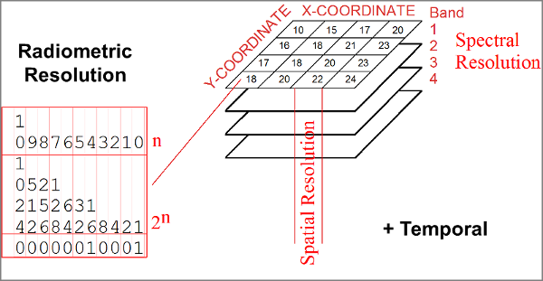
There are four different types of "resolution" for rasters. These resolutions determine the "resolving power" of the raster. This can take some time to be comfortable with so read the material below and then think about it while you work with rasters. Always ask yourself, "what does this raster really capture about the real world in time and space.
This is the resolution we talk about the most. We refer to LandSat as 30 meter data because most of it's bands capture pixels that are about 30 meters across (this varies with latitude). In other words, a 30 meter pixel represents an area on the ground that is 30 meters across.
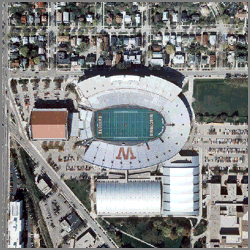
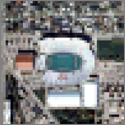
Below is a table with three images of various resolution for the same area. Note that the image on the right captures less detail than the one on the left.
| 1 Meter Resolution | 10 Meter Resolution | 30 Meter Resolution |
 |
 |
 |
You might wonder, "why don't we just always use 1-meter data?". The higher the resolution of the image, the more expensive it is to capture, process, and distribute. Part of this is just the size of the image. If we have a raster of an area that is 100 kilometers (100,000 meters) on each side, and contains just 1 band at 8-bits per band, then the size of the raster for each resolution is:
| 1 Meter Resolution | 10 Meter Resolution | 30 Meter Resolution |
| 100,000 x 100,000 = 10,000,000,000 | 10,000 x 10,000 = 100,000,000 | 3,000 x 3,000 = 9,000,000 |
| 10 Gigabytes | 100 Megabytes | 9 Megabytes |
You can see that as the spatial resolution increases, the size of the raster goes up by the increase in resolution squared! This makes spatial resolution critical to control as we need enough resolution to see what we are interested in on the ground but not so much that we cannot process the data effectively.
We've already mentioned how rasters can have different numbers of bands. black and white photos contain 1 band while RGB images contain 3 and LandSat contains 7. Each band represents a range of spectral values from the eletro-magetic spectrum. The range of the spectrum that each band captures and the number of bands is the "spectral resolution".
1 band image with just "gray scale" data.
3-band image with Red, Green, and Blue
It's often easy to forget that rasters represent one snapshot in time for our earth. As soon as the raster data is captured, the earth continues to change. This means the raster really only represents a short space of time. In addition, for some rasters, such as LandSat, we get snapshots twice a month while those for MODIS are twice a day. These are the temporal resolutions for remotely sensed data but any raster layer will have a period of time it is valid for.
St. Helens before the eruption
St. Helens after the eruption
The last resolution we have is the number of bits for each band of the raster. 8-bit used to be very typical but it only allows values from 0 to 255 or 256 values in all. Some of the newer satellites can produce more than 256 levels of intensity for each band in a pixel so you will see 16-bit remotely sensed data. DEMs have always been distributed as 16-bit integers because Mount Everest is 29,029 feet high (8,848 meters) so we need a 16-bit value (from -32,767 to +32,767) to capture the full range of elevations on the earth.
Selecting the correct resolution for your rasters can determine if you can complete the task before you so it is important to keep track of the resolutions. The image below may help you to remember the four different resolutions.
© Copyright 2018 HSU - All rights reserved.