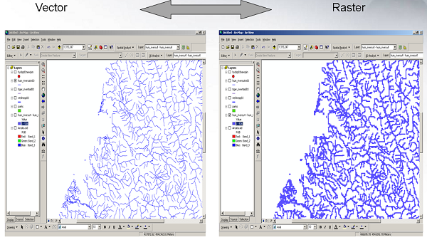
Raster To Vector
Many features can be represented as rasters or vectors. You'll want to select the data type based on the nature of the data and the analysis you want to perform on it.
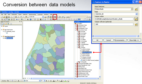
Conversion Between Data Models
You can convert data between rasters and vectors but the nature of the data will be very different.

Below is an example of watersheds in Humboldt County represented as Shapefiles. The "Feature To Raster" tool will convert these polygons to rasters.
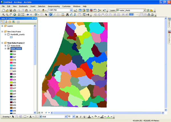
The image below looks very similar to the one above but now the watersheds are represented as rasters.
Problems Associated with Conversion
Whenever you convert data from raster to vector or vector to raster, you will degrade the data by some amount. Issues include:
- Loss of detail
- Loss of accuracy
- Stair stepping (raster to vector)
- Changes to the original data
Choosing Between Data Models
"Raster is faster but vector is corrector"
This is a common saying in GIS. More detailed guidelines are:
- Raster data is useful when:
- Working with continuous data types: elevation, slope, satellite photos
- Good for large area analyses
- Good for surface analysis
- Mathematical modeling
- Spatial detail isn't important
- Vector data is useful when:
- Working with discrete data types: trees, buildings, property boundaries
- Good for small study areas
- Spatial detail is important (When "close enough" isn't really good enough)
- When topology is needed for the analysis
Other factors that can influence your decision include:
- Available storage: some rasters are really large
- Expected types of analysis: some tools only work with raster or vector data
- Expertise of human operators
- Level of accuracy desired
Conversions
The following are examples of tools in ArcMap will convert rasters to vectors or vectors to rasters:
- Raster to Points:
- Raster to Polyline:
- Contour
- Stream to Feature
- Raster to polyline
- Cost Path
- Raster to Polygon
- Viewsheds
- Watersheds
- Raster to Polygon
- Point to Raster
- Interpolation tools: Kriging, IDW, Splines, etc.
- Density tools: Kernel density
- Point to Raster
- Polyline to Raster
- Polyline to Raster
- Raster Domain
- Polygon to Raster
- Polygon to Raster
- Raster Domain
- Topo to Raster
Note: Digitizing is where you convert raster data into vector data!
Test Your Knowledge