GSP 270: Introduction to Geographic Information Science
Results of Changes from fall of 2013 to fall of 2014
During the summer of 2014 we received a Lottery Fund grant to create a series of online learning modules for the GSP 270: Introduction to Geographic Information Science (GIS) class. During this period, we worked with students to create new and innovative labs to help keep the students engaged with GIS throughout the semester and made other changes to the class format. The end result was an increase of students receiving a passing grade of “C” or above from 71% in 2013 to 88% in 2014 (Figure 1). In the fall of 2013 there were 38 students enrolled in the class in the fall of 2013 and 108 students in the fall of 2014. The final reports for the 2014 class were impressive enough for us to request the name of the class be changed from “Introduction to GIS” to just “GIS”.
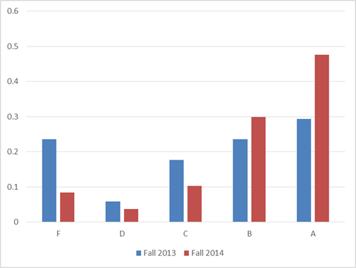
Figure 1. Proportion of grades from the original class in fall of 2013 and the updated class in the fall of 2014.
We believe the reasons for the improvement were:
- Engaging labs created primarily by other students. This includes “Creating your own island” and “Planning a music festival”. We’ve also seen reduced levels of complaints about the content being specific to one discipline.
- All course materials being available to students online.
- Providing “pop quizzes” periodically to encourage students to attend and study material throughout the semester.
- The majority of the students in GSP 270 in the fall of 2014 have taken GSP 101 while many had not in the previous year. GSP 101 provides a foundation for students across all geospatial disciplines (GIS, Remote Sensing, Cartography, and Geographic Positioning Systems (GPS)). This provides the students with a broad knowledge base to immediately move into working with spatial data and allowed us to add a team-based project to the class.
- Provided an incentive to attend class and labs by allowing them to take a 1 question final if they only missed 1 or fewer labs and 1 or fewer quizzes. This proved a successful motivation to have students attend labs and lectures. Over 80% of the students achieved this goal.
- Providing a context for students that most GIS work results in professional reports and then having them complete professional reports in both lab and as their final project.
- Provided a structure for “Doing GIS”. This included; defined folder structure for managing data sets, forms for qualifying data (QAQC forms), and templates of professional reports.
- Added team-projects that started about two-thirds of the way through the semester.
Based on our insights and the feedback from students, I’d recommend the following changes in the future:
- Continue to improve and refine the online learning modules.
- Maintain continuity between the new online and existing face-to-face versions of the class by using the same learning modules.
- To further encourage attendance and performance on assignments, provide students an automatic 100% on the final exam if they: miss 1 or fewer labs, miss 1 or fewer quizzes, and have a grade of B- or above.
- Have the project teams assigned based on the lab sections so students can work together on their projects. The last lab sections will then be used to work on their projects together and present their final reports.
- Expand on the online and software-based education tools to help with geospatial concepts and make the reading of the book optional. This includes providing “Virtual Labs” that allow students to experiment with geospatial concepts in a more interactive and engaging environment than the existing GIS software.