Earth Observing Satellites
Introduction
The age of satellites officially began in 1957 with the launch of Sputnik 1 by the Soviet Union. The United States launched Explorer 1 in 1958. In a few short years in 1960 NASA launched the world’s first weather satellite, TIROS 1. Astronauts soon began to shot photos of the Earth on the Mercury, Gemini and Apollo manned space programs. "The Blue Marble" was the first photograph in which Earth is in full view. The picture was taken on December 7, 1972, as the Apollo 17 crew left Earth’s orbit for the moon. This first clear image of the entire earth quickly became a symbol of the environmental movement.
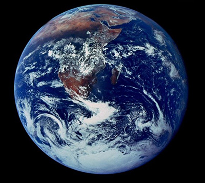 The Blue Marble
 Image Credit: NASA, 1972
Earth Observing Satellites
The collection of The Earth Observing Satellites has grown significantly in the last 50 years. In 1997 NASA launched the Earth Observing System (EOS), which consists of a series of satellites designed for long-term global observations of the land surface, biosphere, solid Earth, atmosphere, and oceans. The program is an international collaboration which includes Canada, UK, Japan, France, Germany and many more.
There have been over twenty satellites launched through the program with approximately 12 satellites still actively collecting data. See the below table for a partial list and description of the Earth Observing Satellites.
| Name | Launch Date | Active? | Description |
|---|---|---|---|
| ACRIMSAT | 12/20/1999 | Retired | Study Total Solar Irradiance |
| ADEOS II | 12/14/2002 | Retired | Monitor the water and energy cycle as a part of the global climate system |
| Aqua | 5/4/2002 | Active | Collect water information in the Earth system |
| Aquarius | 6/10/2011 | Retired | Map the spatial and temporal variations of sea surface salinity |
| Aura | 7/15/2004 | Active | Investigate questions about ozone trends, air-quality changes and their linkage to climate change |
| CALIPSO | 4/28/2006 | Active | Improve understanding of the role aerosols and clouds play in regulating the Earth’s climate |
| CloudSat | 4/28/2006 | Active | Provide the first direct, global survey of the vertical structure and overlap of cloud systems and their liquid and ice-water contents |
| GRACE | 3/17/2002 | Active | Measure Earth's mean and time-variable gravity field |
| ICESat | 1/12/2003 | Retired | Measuring ice sheet mass balance, cloud and aerosol heights, and land topography and vegetation characteristics |
| Jason 1 | 12/7/2001 | Retired | Provide information on ocean surface current velocity and heights |
| Jason 3 | 01/17/2016 | Retired | Provide information on ocean surface current velocity and heights |
| Landsat 7 | 4/15/1999 | Active | Supply the world with global land surface images |
| Landsat 8 | 2/11/2013 | Active | Supply the world with global land surface images |
| Meteor 3M-1/Sage III | 12/10/2001 | Retired | Provide accurate, long-term measurements of ozone, aerosols, water vapor, and other key parameters of Earth's atmosphere |
| NMP/EO-1 | 11/21/2000 | Active | Demonstrate new technologies and strategies for improved Earth observations |
| OCO-2 | 7/2/2014 | Active | Provide space-based global measurements of atmospheric carbon dioxide |
| QuikSCAT | 6/19/1999 | Retired | Acquire global radar cross-sections and near-surface vector winds |
| SeaWiFS | 8/1/1997 | Retired | Provide quantitative data on global ocean bio-optical properties |
| SMAP | 1/31/2015 | Active | Measure surface soil moisture and freeze-thaw state |
| SORCE | 1/25/2003 | Active | Improve our understanding of the Sun |
| Terra | 12/18/1999 | Active | Provide global data on the state of the atmosphere, land, and oceans |
| TRMM | 11/27/1997 | Retired | Monitor and study tropical rainfall |
In addition to the EOS program, there are many other earth monitoring satellites maintained by other countries and commercial satellite launched by private companies.