
Vegetation Indices
Introduction
The most common and frequently used indices are vegetation indices. These indices are designed to indicate the relative density and health of vegetation. Nearly all of these indices compare the reflectance in the red and near-infrared bands. As we learned in an earlier module, healthy vegetation reflects a significant amount in the near-infrared portion of the spectrum and reflects minimal in the visible (specifically the red). this is because chlorophyll in plant leaves strongly absorbs visible light for use in photosynthesis and the cell structure of the leaves strongly reflects near-infrared light. Many sensors aboard satellites measure red and near-infrared light, therefore vegetation indices can be readily calculated. The data from satellite can produce vegetation indices to create "greenness" maps used to monitor vegetation health, drought effects and changes in plant growth.
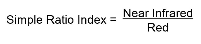
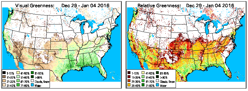 Vegetation greenness maps derived weekly from Normalized Difference Vegetation Index (NDVI) data observed by AVHRR satellites and provided by the EROS Data Center (EDC), U.S. Geological Survey.
Simple Ratio Index (SR):
Simplest ratio-based index is called the Simple Ratio (SR) or Ratio Vegetation Index (RVI). This index is simply the reflectance in the NIR band divided by the reflectance in the red band.
 A larger SR value indicates healthy vegetation, while lower values indicate soil, water or ice. While this index provides a general indication of vegetation, there are a couple of problems with the simple ration index. The first is the issue of dividing by zero. If the reflectance for the red band is zero, it is impossible to produce a SR value for this pixel. There can also be a wide range of possible values depending on the amount of red reflectance. This can make it difficult to compare values. These problems were addressed by development of the NDVI or Normalized Difference Vegetation Index.
Normalized Difference Vegetation Index (NDVI)
One of the most widely used is vegetation index is the Normalized Difference Vegetation Index (NDVI).
Calculations of NDVI for a given pixel always result in a number that ranges from minus one (-1) to plus one (+1); however, no green leaves gives a value close to zero. A zero means no vegetation and close to +1 (0.8 - 0.9) indicates the highest possible density of green leaves.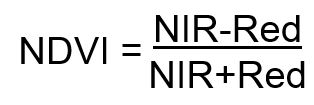 Clear water has a negative NDVI value close to -1. Areas of barren rock, sand, or snow usually show very low NDVI values (for example, 0.1 or less). Sparse vegetation such as shrubs and grasslands or senescencing crops may result in moderate NDVI values (approximately 0.2 to 0.5). Very high NDVI values (approximately 0.6 to 0.9) correspond to dense vegetation such as that found in temperate and tropical forests or crops at their peak growth stage.
When an NDVI is calculated for scientific study, there is some preprocessing that should be done to reduce the effects of clouds, sun angle, and atmospheric effects. even after preprocessing, NDVI is still sensitive to factors such as such as the soil background, especially in areas where vegetation in sparse.
NDVI and Vegetation Maps Online
AVHRR NDVI Greenness Maps - These vegetation greenness maps are derived weekly from Normalized Difference Vegetation Index (NDVI) data observed by AVHRR satellites and provided by the EROS Data Center (EDC), U.S. Geological Survey. These maps are composited weekly and have 1.1-kilometer (0.6 mile) spatial resolution
NOAA STAR Vegetation Health Maps - The National Oceanic and Atmospheric Administration (NOAA) Center for Satellite Applications and Research (STAR) produces a variety of vegetation and soil indices on a weekly basis. The site also includes animations showing the temporal changes.
Food and Agriculture Organization of the United Nations Global Maps- the Food and Agriculture Organization of the United Nations produces global maps showing vegetation health and precipitation levels. the vegetation indicators are based on 10-day vegetation data from the METOP-AVHRR sensor at 1 km resolution.