
Accuracy and Precision
Accuracy
Accuracy refers to how closely a measurement or observation comes to measuring the “true value”. For remote sensing this generally means whether or not the remote sensed derived data represents what is actually on the ground.
Map Accuracy
Map Accuracy refers to the proportion of agreement between a classified map and the reference data that is assumed to be true or correct. Usually this data is known as ground-truth data that has been collected in the field. When we conduct an accuracy assessment at the end of this module we will be calculating the map accuracy.
Thematic Accuracy
Thematic accuracy refers to how well the class name on the map correspond to what is really on the ground.
Spatial Accuracy
Spatial accuracy refers to quantifying errors in the locations of boundaries. Spatial accuracy generally relates to the spatial resolution of the data set. Thematic and Spatial Accuracy are related but are usually addressed separately.
Precision
In remote sensing precision refers to the level of detail of the measurement. Thematic Precision is used to describe the level of detail that is mapped. A map that distinguishes Lodgepole pine, Douglas fir, Ponderosa is more precise than a map just showing Forest.
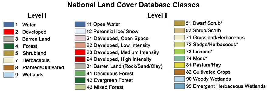
For Example in the National Land Cover Database hierarchical classes show below the first level has less precision, while the next level has a great deal more thematic precision.
There is generally an inverse relationship between accuracy and precision. It is very difficult to produce maps with both a high level of precision and accuracy.